Pre-Packaged Geospatial Data
The datasets to download
Just copy-and-paste the following URLs into the Carto Dataset maker:
https://dannguyen.github.io/sql-carto-journalism-exercises/data/wrangled/atf_firearm_dealers_2016_08.csv
https://dannguyen.github.io/sql-carto-journalism-exercises/data/wrangled/congressmembers.csv
https://dannguyen.github.io/sql-carto-journalism-exercises/data/wrangled/intercensal_county_estimates.csv
https://dannguyen.github.io/sql-carto-journalism-exercises/data/wrangled/presidential_election_state_results.csv
https://dannguyen.github.io/sql-carto-journalism-exercises/data/wrangled/presidential_election_county_results.csv
https://dannguyen.github.io/sql-carto-journalism-exercises/data/wrangled/ccd_schools.csv
https://dannguyen.github.io/sql-carto-journalism-exercises/data/wrangled/chicago_homicides_and_gun_crimes.csv
https://dannguyen.github.io/sql-carto-journalism-exercises/data/wrangled/us_quakes.csv
https://dannguyen.github.io/sql-carto-journalism-exercises/data/wrangled/starbucks_locations.csv
https://dannguyen.github.io/sql-carto-journalism-exercises/data/shapefiles/congress_districts_114th.zip
https://dannguyen.github.io/sql-carto-journalism-exercises/data/shapefiles/us_county_shapes.zip
https://dannguyen.github.io/sql-carto-journalism-exercises/datashapefiles/usgs_hazards_2014.zip
https://dannguyen.github.io/sql-carto-journalism-exercises/data/shapefiles/usgs_fault_lines.zip
https://dannguyen.github.io/sql-carto-journalism-exercises/data/shapefiles/us_state_shapes.zip
https://dannguyen.github.io/sql-carto-journalism-exercises/data/shapefiles/zcta_simplified.zip
For more information about the datasets, here's some context:
CSV data files that lack geospatial coordinates
These datasets may have columns that directly relate to geography, such as a street address or even a Census tract code. But this is not geospatial data that can be directly mapped; for example the street address 100 Broadway, New York, NY, needs to be geocoded and "converted" into a latitude,longitude pair.
This election dataset has state and county names, but for our purposes, we don't think of it as (directly) having geospatial coordinates.
ATF Listing of Federal Firearm Licenses
Members of the 114th U.S. Congress
Census Intercensal Estimates of the Resident Population 2000 to 2010
Presidential Election Results by State
Presidential Election Results by Count (2004 and 2008)
CSV datafiles containing geospatial data
For the most part, this will be latitude and longitude coordinate pairs that can be plotted directly onto a map.
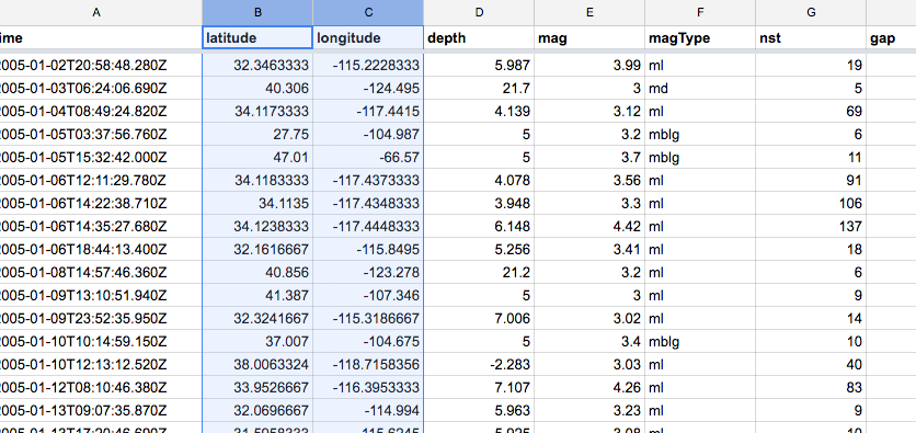
The earthquake data is an obvious example:
School Demographic and Free Lunch Participation
Chicago crime incidents involving homicides or guns
M3.0+ Earthquakes in the Contiguous U.S., 2005 to 2015
Starbucks Locations, worldwide
Shapefiles
When data rows are attached to something more complicated that a lat/long pair – such as the many lat/long points needed to draw a state border, we use shapefiles. Or rather, we download them from one source and upload it to the next. All of these files are zip files, but you don't need to actually unzip them and mess with the files. Just upload the zip file straight to Carto.
Representing earthquake fault lines is more complicated the way earthquakes are often simplified to a point.
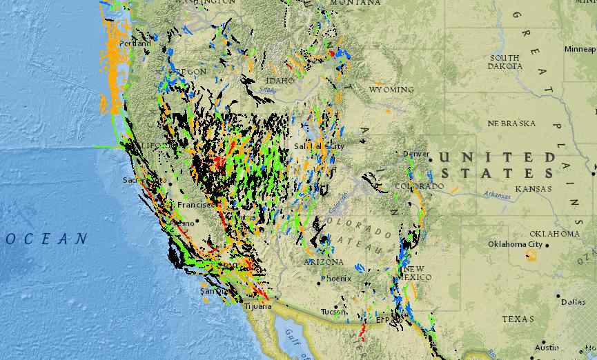
Checkout the USGS interactive fault map here